You Can Still Visit These Six Former National Parks
Despite being delisted by the NPS, these spots are worth exploring thanks to their rich history and sheer beauty
/https://tf-cmsv2-smithsonianmag-media.s3.amazonaws.com/filer/37/48/3748314e-34e5-429d-bcb8-b24a3e559b59/36249616404_acf8ac82f4_k.jpg)
On March 1, 1872, President Ulysses S. Grant signed a bill designating Yellowstone National Park as the first national park in the United States. In the nearly 150 years since, hundreds of other parks have joined the ranks, and today the National Park Service is responsible for managing 423 units spread across more than 85 million acres of land. However, while the NPS has always been adding new parks to its inventory, it has also “pruned” a fair amount too (26 to be exact), for reasons that range from low visitor numbers to safety precautions. But that doesn't mean that these locations aren't worth a visit. Here are six former parks worth the trip for their rich history and sheer beauty alone.
Mackinac Island State Park, Michigan
Years in the NPS (Mackinac National Park): 1875-1895
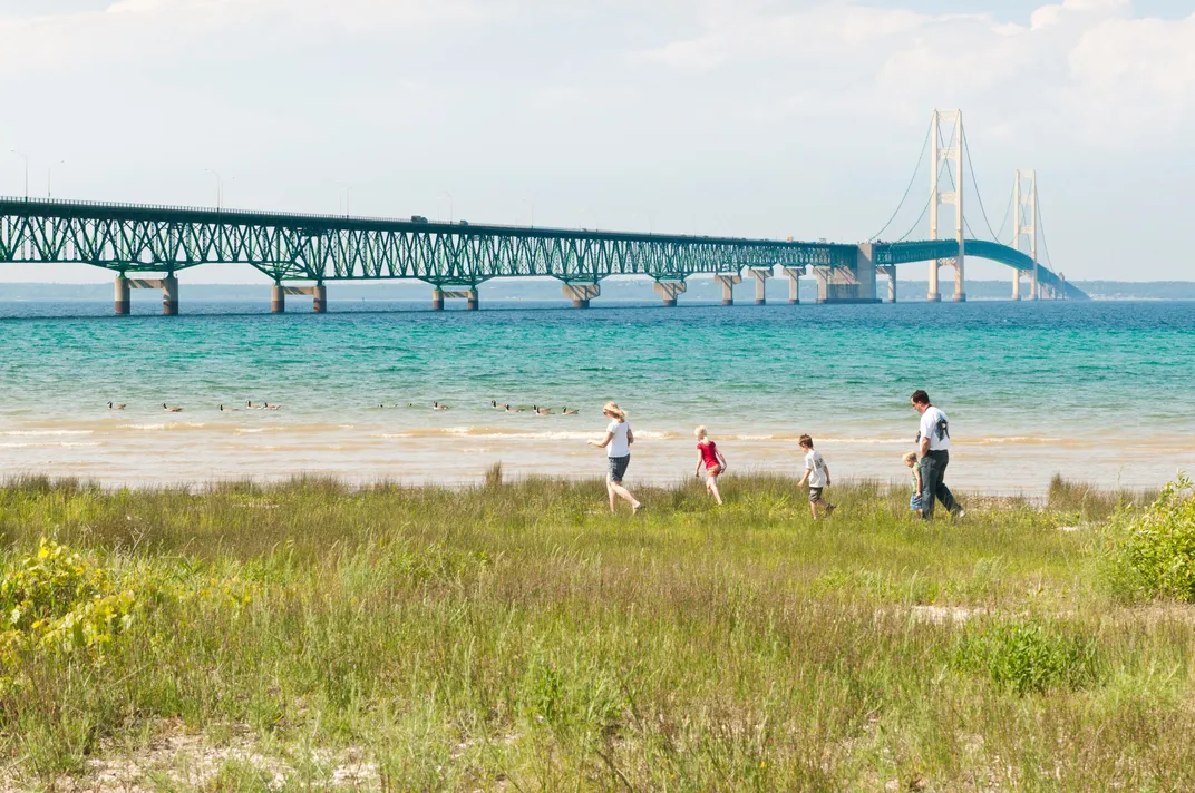
Three years after Yellowstone earned its status as a national park, an island off the coast of Michigan’s upper peninsula became the next in line to join the NPS list. At that time, the approximately four-square-mile island was a popular weekend getaway for the wealthy, who had summer homes (well, mansions) built on the bluffs overlooking Lake Huron. Before that, the island was home to the Odawa, a Native American tribe that was well known as fur traders. However, European colonization pushed them out, and eventually Mackinac Island became an important military stronghold during the War of 1812.
Once the dust from the war settled, Mackinac Island remained home to Fort Mackinac, a military garrison. Seeing an opportunity, in 1875, Congress assigned the U.S. Department of War as the party responsible for managing the new national park, tapping military personnel to help with its operation. But by the 1890s, the military no longer had a need for a base there and threatened to abandon their stewardship, causing Michigan’s governor to petition Congress to turn the park over to the state. In the roughly 125 years since, the island has remained Mackinac Island State Park, a slice of paradise in the Great Lakes region where motor vehicles are banned and visitors travel the rolling two-lane roads via bicycle or horse and buggy. The island has become a popular destination for hikers thanks to its abundance of interesting rock formations, including Arch Rock, a naturally formed limestone arch that rises 146 feet and was one of the geological anomalies that put the island in the running to become a national park in the first place.
Crow Flies High State Recreation Area, North Dakota
Years in the NPS (Verendrye National Monument): 1917-1956
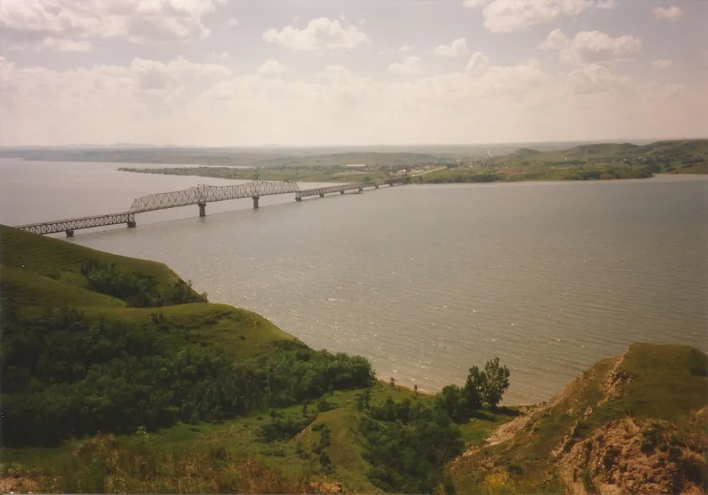
Thanks to its exaggerated craggy shape, which stands in stark contrast from the surrounding flat terrain along the banks of the Missouri River, Crowhigh Butte became a popular point of navigation for pioneers traveling during the western expansion of the 1800s. The notability of the 565-foot landform also caught the attention of Congress, which, by presidential proclamation in 1917, granted it and its surrounding 250 acres as Verendrye National Monument, naming it after French-Canadian explorer and fur trader Pierre Gaultier de Varennes, sieur de La Vérendrye.
At the base of the peak sits a plaque that reads:
“The Verendrye National Monument. Established June 29, 1917. To commemorate discovery of this area in 1742 by the Sons of Verendrye, celebrated French explorer. Crowhigh Mountain was used as an observation station to spy out unknown land farther west. In 1738 the elder Verendrye and one son made a trip to within a day's journey of the Missouri River, and were the first white men to enter what is now North Dakota. This was in the course of a journey from Verendrye's trading post in Manitoba, Canada, in an effort, which was unsuccessful, to reach the western sea by an overland route."
By the 1950s, historians began questioning the accuracy of the explorer’s claims of camping at Crowhigh Butte, and in 1956, Congress declassified the monument, transferring it to the state of North Dakota, which renamed it Crow Flies High State Recreation Area. However, its main draw remains the same with modern-day explorers: The views are worth the journey.
Shasta-Trinity National Forest and Whiskeytown-Shasta-Trinity National Recreation Area, California
Years in the NPS (Shasta Lake Recreation Area): 1945-1948
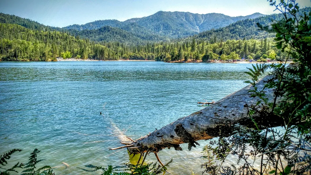
Out of all the sites once under the NPS umbrella, the Shasta Lake Recreation Area had one of the shortest stints, clocking in at three years. In 1945, the NPS took the property on as national parkland. This was right around the same time that California’s Central Valley Project, a network of dams, reservoirs and canals, broke ground along the Sacramento River. Part of the project was the construction of what would become Shasta Lake, a manmade reservoir, and Shasta Dam. At that time, the curved concrete dam, which sits about 14 miles north of Redding, was considered an architectural marvel. Construction took more than four years to complete, and once finished, the 602-foot spillway made it the second tallest dam in the United States after the Hoover Dam.
Today, the National Forest Service manages most of the property, which has been subdivided into the approximately 2.2-million-acre Shasta-Trinity National Forest and the 246,087-acre Whiskeytown-Shasta-Trinity National Recreation Area. However, the NPS remains in charge of one portion, Whiskeytown National Recreation Area, a 42,000-acre area that was once a thriving gold mining town. Years later, the ghost town’s buildings have been submerged by flood waters from the dam but can still be spotted by eagle-eyed scuba divers and snorkelers. All three are popular destinations for boaters and hikers, and wildlife is abundant, ranging from bald eagles and mountain lions to North American river otters and Western pond turtles.
Lewis and Clark Caverns State Park, Montana
Years in the NPS (Lewis and Clark Cavern National Monument): 1908-1937
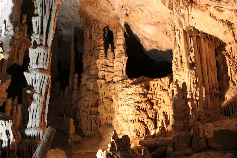
Named after Meriwether Lewis and William Clark, this site overlooks the same trail that the American explorers traveled as part of the Corps of Discovery, a U.S. military mission that took place between 1804 and 1806 to explore previously uncharted parts of the West. Interestingly, the duo never set foot inside the caverns, which wouldn’t be discovered for another 86 years by a pair of hunters who stumbled upon them. A few years later, the hunters opened it up to public use, dubbing it Limespur Cave.
In 1908, the NPS scooped the property up and renamed it the Lewis and Clark Cavern National Monument. It would become the system’s 15th national monument. Despite being only 50 miles west of Bozeman, the site never drew crowds, since the roadways to get there were in such poor condition. (There was also a treacherous 45-minute uphill hike involved too.) If they made it to the entrance point, they were on their own, as no park rangers were on site. Couple that with no interior lighting inside the cavern, and it's easy to see why tourists bypassed the park. Because of safety concerns, the NPS officially closed the caverns in 1937.
Soon thereafter, the Civilian Conservation Corps swooped in and added some much-needed improvements to the caverns, and in 1937, Congress transferred the property to the state of Montana, making it the state’s first state park. Now known as Lewis and Clark Caverns State Park, the 3,000-acre site claims to be “the most highly decorated limestone caverns in North America,” as it is lined with stalactites, stalagmites, columns and helictites.
La Garita Wilderness, Colorado
Years in the NPS (Wheeler Geologic Area): 1908-1950
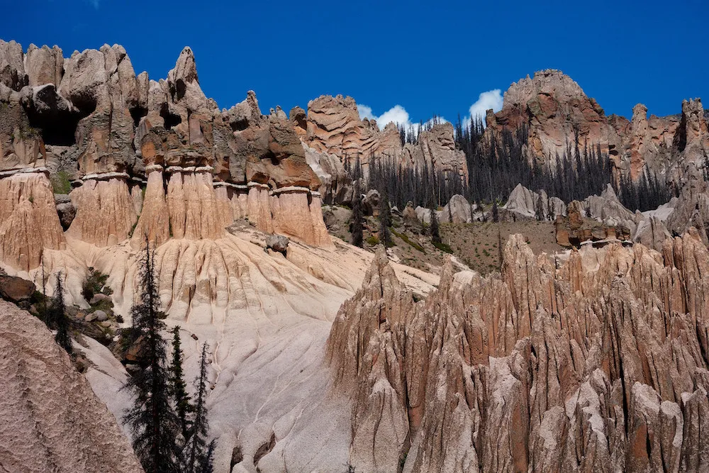
The future of the Wheeler Geologic Area as a tourist destination was doomed from the start. Despite being visually captivating thanks to its rocky outcroppings and jagged spires, very few visitors were willing to make the arduous journey through southern Colorado to see this natural spectacle. Part of the reason was because there were no good roads leading to it, and by the middle of the 20th century, once car travel was firmly rooted in American culture, many tourists would continue driving past the site in favor of more accessible destinations that were equally stunning, like Pike’s Peak to the northeast.
Because of low visitor numbers (according to one source, only 43 people visited in 1943), Congress transferred the site to the U.S. Forest Service, the same agency that was responsible for it before the NPS. It would be Colorado’s first national monument. Today the site, which sits inside the 1.86-million-acre boundaries of the Rio Grande National Forest, remains in the hands of the U.S. Forest Service and has been merged into the adjacent La Garita Wilderness.
Today, the geologic area is far more accessible and has become a popular destination among rockhounds interested in exploring the unusual geological formations, which are the result of volcanic ash that has been compressed into the rocks and eroded over time, revealing a mesmerizing profusion of spires, domes, caves and ravines known as “The City of Gnomes.”
Chattanooga National Cemetery, Tennessee
Years in the NPS: 1933-1944

After the NPS transferred the Chattanooga National Cemetery to the War Department in 1944, the cemetery retained its name, unlike many other former units. Located in Tennessee, the cemetery has a long and storied history that dates back to the Civil War. In 1863, during the Battle of Missionary Ridge, Union Major General George Thomas called for a cemetery to bury soldiers killed in action during the Battle of Chattanooga and the Battle of Chickamauga. On Christmas Day, Thomas issued an order creating a cemetery on 75 acres of land located a mile’s drive from what is now downtown Chattanooga. All told, tens of thousands of soldiers were buried there, including 1,800 unknowns.
Once the war ended, the U.S. government purchased the land along with some property adjacent to the parcel and began burying disinterred soldiers who hadn’t received formal burials during the war. In 1933, the cemetery joined the NPS’s growing list of parks only to be delisted 11 years later.
The Chattanooga National Cemetery is renowned for several reasons. First, it’s the only national cemetery to contain graves of foreign POWs, including 78 graves of Germans from World War I and 108 POWs from Germany, France, Italy and Poland from World War II. The cemetery is also notable for its interesting layout, the work of U.S. Army Chaplain Thomas B. Van Horne, who was inspired by the area's undulating topography, resulting in burial sections in unique shapes like circles and triangles. There are a number of significant burials within the cemetery, including Master Sergeant Ray E. Duke, who received the Medal of Honor posthumously for his service during the Korean War, and Cal Ermer, a Major League Baseball player and Marine Corps vet of World War II.